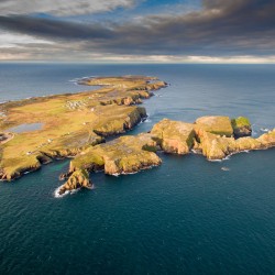
Clare Island – Oileán Chliara


Clare Island lies 5 km off the west coast of Mayo at the entrance to majestic Clew Bay. It is 7 km long and, at its broadest, 5 km wide, and rises to a height of 462 metres at Knockmore. The island is a mix of semi-natural and improved grassland, maritime sward and heath and precipitous … Continued

Read More

Cape Clear – Oileán Chléire


Cape Clear (Oileán Chléire) lies 12 km off the southwest coast of Ireland, in the mouth of Roaringwater Bay. Irish is spoken on Chléire, and it is the most southerly Gaeltacht area. Indeed, Cape Clear is the most southerly inhabited part of Ireland.

Read More

Tory Island – Oileán Thoraí


Oileán Thoraí (or Tory Island) lies 14.5 km off the northwest coast of Donegal. It is a special island, with unique character and heritage. About 170 people live on the island, and Irish is the native tongue. In recent years the island has become home to a flourishing artistic community.

Read More

Bere Island – Oiléan Béarra


Bere Island lies at the entrance to the magnificent Bantry Bay in Co. Cork and guards Berehaven Harbour, one of the deepest harbours in Europe. The island lies 2 km offshore from the town of Castletownbere. Just over 200 people live on the island.

Read More

Inis Mór


Inis Mór is the largest of the three Aran Islands that lie in the mouth of Galway Bay. It is 14 km long and no more than 4km wide, with an area of 31 km2. Irish is still the native tongue, and it is a Gaeltacht area.

Read More

The National Biodiversity Data Centre is an Initiative of the Heritage Council and is operated under a service level agreement by Compass Informatics. The data centre is funded by the Department of Arts, Heritage and the Gaeltacht and the Heritage Council.
© 2024 BioBlitz | Web Design Vitamin Studio